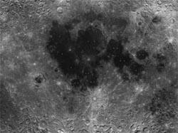
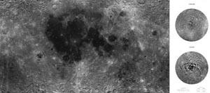
The country's first full map of the Moon has recently been released by the State Administration of Science, Technology and Industry for National Defense. The image, which was produced on the basis of data obtained by the Chang'e-1, China's first lunar probe, over the past one year or so, was presented to the National Museum of China on 12 November in Beijing.
About one year earlier, on 24 November, 2007, Chang'e-1 blasted off on its way toward the moon, making a new milestone in the country's space exploration history. Two days later, China unveiled its first lunar surface picture, which was taken by the CCD 3-D camera, a brainchild of scientists from the CAS Xi'an Institute of Optics and Precision Mechanics. Later on, in January 2008, China released images of the polar regions of the Moon taken by this camera. Until 12 May, 2008, the camera had shot pictures of lunar terrain surface between 70 degrees of both North and South Latitudes of the moon. At the same time, a full image of the Moon surface was produced on the basis of the data collected.
According to experts, the approaches by which the CCD camera aboard the lunar probe works are different distinctively from those of conventional ones: it makes images "track by track." During each obit around the moon, the CCD camera scan one track of the lunar surface, covering an area of 60 km in width and about 10900 km in length. Using linear array push-broom imagery technology, the camera can simultaneously have forward, nadir and backward images of the track. The newly released the image is a reconstruction of the terrain surface of the Moon on the basis of the information from nearly 560 such tracks after a series of rectifications in terms of radiation, geometry and optics. It covers an area of West Longitude 180 degrees to the East Longitude 180 degrees, between the North and South latitudes of 90 degrees.
It was the most complete image of the Moon surface, and also the richest in detail, among similar pictures published so far. Its quality reached the world's advanced level and is spoken highly by experts at a meeting of its acceptance check.
Related News
Photos
More>>


trade
- CAS to start planning for coal chemical industry development in Xinjiang
- Snow leopard spotted in high-altitude area on world roof
- Institute of Electronics to set up a new campus at the foot of the Great Wall
- CAS scientists report a meteorite from the far side of the Moon
- Int'l workshop on management innovation convenes in Beijing