Guilin
- Things to do
-
- Photo(347)
- Tips&article(120)
- Make it Happen
- Map
-
loading...
- Other Tours
-
- Reed Flute Cave
- Crown Cave
- Stone Forest
- Gudong Waterfall
- Longji Terraced Field
- Seven Star Park
- West Hill Park
- Seven Star Cave
- Chuanshan Park
- Mausoleums Jing Jiang
- Two Rivers And Four Lakes
- Guilin
- Taohua River
- Li River
- Yueling Village
- Banyan Lake And Cedar Lake
- Bajiao Zhai Geography Park
- Yao Mountain
- The Ling Canal
- Cat Mountain
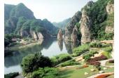
Guilin's idyllic scenery draws tourists from near and far by their hundreds of thousands every year. The primary industry of Guilin is tourism, so travelers feel well-catered-for and immediately relaxed in this small and quiet, but hugely popular city. It is never far to the next colorfully named karst hill or charming vista in Guilin's countryside. You will find a paradise to relax in, and plenty of rural/minority culture to enjoy.
Accolades
- Guilin's reputation as one of the world's most beautiful places has been established over hundreds of years and ranks second on China's list of the 10 best tourist destinations, after Beijing.
- The popular Chinese saying 桂林山水甲天下, Guilin shanshui jia tian xia means ‘Guilin’s mountain and water scenery is the best under heaven’. The Li River, Guilin's most popular scenic area, was selected by National Geographic Magazine as one of the world's top ten watery wonders.
- "I have visited more than 80 countries and over a hundred cities. I
have found that no city can surpass the beauty of Guilin."
"Guilin is really a bright pearl in China."
- Former US President Nixon
History
Guilin was named after the fragrance of the osmanthus tree (Gui means osmanthus and lin means forest). Its first recorded inhabitants lived in the Qin Dynasty (221-206 BC). Guilin prospered and flourished during the Tang (618-907), Song (960-1279), Ming (1368-1644) and Qing (1644-1911) dynasties under patronage from successive emperors. It is currently home to 12 ethnic minorities.
Features
Guilin Prefecture is an area of 28,000 square kilometers (11,000 square miles) located in the northeast of Guangxi Zhuang Autonomous Region, South China. See Guilin Maps. Guilin City is small by Chinese standards, with about 700,000 people, located about 500 km (300 mi) northwest from Hong Kong, about one hour away by air. See Guilin Transport.
Guilin is in a subtropical (bordering temperate) monsoon zone with a warm and moist climate. See Guilin Weather. Altitude ranges from about 100 meters in the lower reaches of the Li River to 2,141 meters at Kitten Mountain, the tallest peak in South China and source of the beautiful Li River. The Li River flows through Guilin from north to south. The center of Guilin city lies on the western bank of the Li River.
Karst Scenery
Guilin has some of the most spectacular karst topography in the world. The tooth-like limestone mountains come in clusters, or as isolated monoliths or mesas, often with caves, and sometimes with holes all the way through, like Elephant Hill and Moon Hill in Yangshuo.
Famous people and poets down through the centuries have eulogized Guilin. It really has to be seen to be believed. The mountains are so sheer they come vertically out of the ground in places. Their white and black faces are cloaked in verdant greenery. They are best viewed where a river or lake reflects their profiles, or when the post-rain mists cling to the pinnacles.
The mountains were formed by uplifting of the earth’s crust in this region, which was, according to some theories, once underwater, because of the number of caves systems even high up in some hills. Over the years the rains have dissolved away the softer limestone, leaving these remarkably angular chunks of rock.
Attractions in the City
Elephant Trunk Hill
Elephant Trunk Hill is the symbol of Guilin and its karst
landscape. It looks like a huge elephant stretching its trunk and
drinking water, hence the name.
Seven Star Park
Seven Star Park is named after the seven larger karst hills in it.
There is plenty to see here with peaks to ascend, a zoo, free
roaming monkeys, Seven Star Cave, Camel Hill, beautiful gardens and
stele, and locals dancing.
Reed Flute Cave
Reed Flute Cave is a fascinating gallery of limestone cave
formations, now enhanced by multicolored lighting, which has been
one of Guilin’s attractions for over 1200 years.
More Guilin Attractions
Attractions Near the City
The Li River
The Li River, particularly between Guilin and Yangshuo, is one of
the most beautiful sights on the planet. It is best experienced
with a cruise or a leisurely hike along its banks.
Yangshuo
Get "up close and personal" with the beauty that you have seen in
the pictures as you venture out into the countryside of Yangshuo by
bicycle or bus, through the rice paddies to experience rural China
at its most charming.
Longsheng’s Rice Terraces
Longsheng County boasts fantastic natural scenery with spiraling
rice terraced fields that were built about 700 years ago. It is
famous for its ethnic villages in mountainous areas.
Guilin’s Top Tours
4-Day Guilin's Facinating Neighbors Tour
- Tour Code: GL-7
- Attractions: Li River Cruise, Yangshuo, Longsheng’s terraced fields, Reed Flute Cave, Elephant Trunk Hill, and Fubo Hill
Itinerary & Price Details »
$479
4-Day Guilin & Yangshuo Memories Tour
- Tour Code: GL-7
- Attractions: Li River Cruise, Yangshuo, Longsheng’s terraced fields, Reed Flute Cave, Elephant Trunk Hill, and Fubo Hill
Itinerary & Price Details »
$334
4-Day Longsheng Terraced Field & Yangshuo Combo
- Tour Code: GL-7
- Attractions: Li River Cruise, Yangshuo, Longsheng’s terraced fields, Reed Flute Cave, Elephant Trunk Hill, and Fubo Hill
Itinerary & Price Details »
$456
More Guilin Tours
For a tailor-made tour including Guilin contact us.
Tips & articles
|
|
|
forum discussion
|
|
|


