Karez Well
- Things to do
-
- Photo(13)
- Tips&article(7)
- Make it Happen
- Map
-
loading...


Top 5 Lists

Features
1. Museum in Turpan about the karez ancient irrigation system.
2. Instructs on the history and technology of the karez irrigation system.
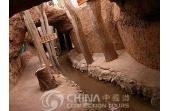
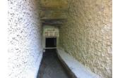
3. Has an underground tunnel to see.
Overview
In order to get enough water in the area of Turpan for themselves and the caravan traders and others passing through and for agriculture and their cattle, long ago people dug long underground tunnels that brought the flowing water from the mountains to the north. These tunnels have vertical access tunnels that were spaced at intervals that allowed people to bring up water in buckets or to go down into the tunnel for repairs.
These access tunnels had mounds around them, and the long lines of mounds stretching into the horizon looked like rows of gigantic ant hills. The system helped to make the Turpan area an oasis stopping place on a Silk Road route. The Turpan Karez Museum (吐鲁番坎儿井博物馆) is also called the Turpan Water Museum.
The museum has pictures and models instructing on the history of the karez system, and there are underground tunnels people can walk around in and see a karez.
Turpan lies in the second or third deepest inland depression in the world, and along the northern rim of the depression there is a range with high mountains and snow capped peaks called the Bogda Mountains. There is a lot of water in the mountains, but to bring it down to the basin without the water evaporating and being lost by ground seepage as in surface canals, the locals had to make underground tunnels. The locals took advantage of the big difference of elevation to make sloping underground tunnels to bring water.
History
These karez are like qanats that were used in Persia and the Middle East. It is not known who originated this technology. It is said that qanats started to be used in Central Asia about 800 BC. It is also not known when the first karez was dug to the Bogda range in the Turpan area. For people with only iron-age tools, digging these tunnels was practical. They could be dug and maintained using simple tools, buckets and draft animals to help pull up the dirt.
During very ancient times when caravan traders passed through the area as they went to or from the Gansu Corridor to the east, the Turpan area was a place to trade, get provisions and rest. There were a string of forts, cities and small kingdoms along the northern rim of the Turpan Basin and the Taklamakan Desert.
In the Turpan area, there were two fortified cities called Jiaohe and Gaochang about 44 kilometers apart. These caravans needed fodder for the camels and other animals and food for the guards, traders and travelers. So there was a high demand for water and food to support the traffic through Turpan, and it is said that karezes were used to supply some of the water.
After a period of interruption of the trade, Silk Road trade prospered during the Yuan Dynasty (1279-1368 A.D). The Yuan Dynasty was the Mongolian Dynasty of China. The Mongolians conquered China and many other countries, and they made a big Eurasian empire stretching from Korea to Hungary, and they guarded their trade routes.
They destroyed both Gaochang and Jiaohe, but they encouraged trade through the area. But when their empire collapsed, regional conflicts interrupted trade. After the 1500s, merchant ships made the northern Silk Road routes mostly unnecessary for long-distance trade, but people continued using the karezes until modern times.
Most of the karezes in the Turpan area were built during the Qing Dynasty era or before 1949. They still help to make Turpan an important fruit and vegetable growing area in China, but now spring water, surface canals and wells supply most of the water used for agriculture. It is said that in 1949, about 600 karez were in use and they supplied most of the water used for irrigation.
But in modern times, concrete canals and ditches were built and pipes were installed, and hundreds of wells were dug. Now only about 300 karez are still used, and they supply about 16 percent of the water for irrigation in the Turpan area.
Touring Activities
1. Learn about karezes and some of the history of the Silk Road.
2. Learn about the agricultural practices of the local people.
3. See the tunnels.
4. Go to the nearby Turpan Museum to see mummies, Manichean art, and Silk Road artifacts.
Travel Essentials
Location: The Karez Museum (坎儿井博物馆) is about three kilometers or 1.5 miles west of the center of Turpan.
Nearby Attractions
To learn more about Turpan, there is a Turpan Museum on Gaochang Road. It is basically in the center of town about three kilometers east of the Turpan Karez Museum. Three main halls in the museum deal with a fossilized Giant Rhinoceros, archeological artifacts, and mummies. There are Manichean artworks.
The archeological sites of Turpan of the Jiaohe Ruins, the Bezeklik Grottoes, the Astana Tombs and the Gaochang Ruins are all within about 40 kilometers travel east or west.
If you are interested in learning about Xinjiang and its ancient history, one of the highlights in Xinjiang is the Xinjiang Uygur Autonomous Region Museum (Qu Bowuguan, 新疆维吾尔自治区博物馆). It is famous for having the artifacts and mummies of Caucasians who lived in the region between 1,500 and 4,000 years ago. A whole culture and perhaps an entire civilization have been discovered in Xinjiang in the past twenty years. It wasn’t known that the Caucasian settlements existed
In Urumqi, there are three other museums called the Urumqi Museum (乌鲁木齐博物馆) on South Nanhu Road 123 (南湖南路 123); the Xinjiang Geological and Mineral Museum on Youhao Road; and the Xinjiang Silk Road Museum (新疆丝绸之路博物馆) at No. 160 Shengli Road. The last museum about the Silk Road is next to the Grand Bazaar shopping area that is also called the Erdaoqiao in Chinese.
visitors can get the Karez Water System Folkways Center by bus.How to Get to there?
Tips & articles
|
|
|
|
|
forum discussion
|
|
|
|
|