On mentioning the southern Xinjiang Uyghur Autonomous Region, people's minds will conjure up a picture of the rolling Pamir Mountains, impassable Taklamakan desert, ancient Silk Road with the long camel team and the sounds of bells. Due to the vast territory and scattered scenic sights, visitors are well advised to go there by car.
Itinerary: Urumqi Hetian Kashgar Aksu Kuche Turpan
Time: 10 to 20 days
Distance: 5,000 km
What to see:
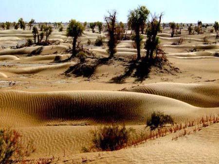
Taklimakan Desert
The Taklamakan Desert (Chinese: ; pinyin: T k l m g n Sh m ), also known as Taklimakan, and Teklimakan, is a desert in Central Asia, in the Xinjiang Uyghur Autonomous Region of the People's Republic of China. It is the world's 17th largest desert. It is bounded by the Kunlun Mountains to the south, and the desert Pamir Mountains and Tian Shan (ancient Mount Imeon) to the west and north.
It covers an area of 270,000 sq km (100,000 sq mi) of the Tarim Basin, 1,000 kilometers (620 mi) long and 400 kilometers (250 mi) wide. It is crossed at its northern and at its southern edge by two branches of the Silk Road as travelers sought to avoid the arid wasteland. In recent years, a cross-desert highway that links the cities of Hotan (on the southern edge) and Luntai (on the northern edge) were constructed. The desert has expanded in some areas, its sands enveloping farms and villages as a result of desertification.
There is very little water in the desert and it is hazardous to cross. Merchant caravans on the Silk Road would stop for relief at the thriving oasis towns.
The key oasis towns, watered by rainfall from the mountains, are Kashgar, Marin, Niya, Yarkand, and Khotan (Hetian) to the south, Kuqa and Turpan in the north, and Loulan and Dunhuang in the east. Now many, such as Marin and Gaochang, are ruined cities in sparsely inhabited areas in Xinjiang.
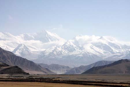
Pamir Mountains
The Pamir Mountains (Chinese: ; pinyin: P m ' r G oyu n) are a mountain range in Central Asia formed by the junction or knot of the Himalayas, Tian Shan, Karakoram, Kunlun, and Hindu Kush ranges. They are among the world's highest mountains and since Victorian Times they have been known as the "Roof of the World", translated from "Pamir".
Historically, the Pamir Mountains were considered a strategic trade route between Kashgar and Kokand on the Northern Silk Road. The Northern Silk Road (about 2,600 km (1,616 mi) in length) connected the ancient Chinese capital of Xi'an to the west over the Pamir Mountains to emerge in Kashgar before linking to ancient Parthia.
Hetian Bazaar
Hetian Bazaar is nearly as big as the Sunday Market in Kashgar. It is located in the northeast of Hetian and covers a large area of 118,352 square meters. The multi-functioned market sells Uyghur fruits, medicine, livestocks, secondhand goods, lacquerwares and china. The products include jade, silk, carpets and handmade woodwork.
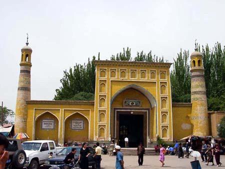
Id Kah Mosque, Kashgar
The Id Kah Mosque (Chinese: ; pinyin: it g r) is a mosque located in the central square in Kashgar, Xinjiang. It is the largest mosque in China. Every Friday, it houses nearly 10,000 worshippers and can accommodate up to 20,000. In English, "Id Kah" means a place for celebrating and praying in festivals. The mosque is famous for the old Islamic buildings featured with strong ethnic styles.
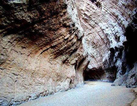
Kuqa (or Kuche) Gorge, Aksu
Located to the south of Tianshan Mountain, about 60 kilometers to the north of Kuqa county in Aksu, Xinjiang, Kuqa Gorge is a tributary of the Tarim River. It is made up of huge red mountains which are called "Kizilia" by locals. The gorge extends more than 5,000 meters and is composed of a main valley and seven branch valleys.
Grape Valley, Turpan
Located in the western slope of the Flaming Mountain, about 13 km to the northeast of Turpan, Grape Valley is a green paradise boasting for the layers upon layers of grapes. Besides grapes, mulberries, apricots, peaches, pomegranate, apples and pears are all covered the slope sides of the valley, making the valley display of colors and sending off fragrance in miles. The idyllic beauty of the valley makes a sharp contrast of the dry, barren and boiling outside.
What to eat: mutton and seasonal fruits
What to buy: pocket knife made in Yingjisha, Hetian jades, handmade carpets and musical instruments.
Related News
Photos
More>>


trade
market
finance
- Sevilla Strengthen European Bid While Espanyol Slip Up
- La Liga Round-up: Barcelona Reopen Big Lead Beating Mallorca While Madrid draw
- Serie A Round-up: Inter Move to Second after Win over Sampdoria
- Manchester City and Liverpool Reach Last 16 in Europa League
- Gattuso Scores as Milan Beat Juventus 1-0