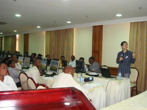
The Training Workshop on The Use of Remote Sensing and GIS for Biosphere Reserve Management in the Light of Climate Change convened in Arusha, Tanzania. It was co-organized by the UNESCO Office in Dar es Salaam, and Dar es Salaam University College of Resource Management (IRA). The Tanzanian government and UNESCO attached great importance to this workshop through which the Tanzanian scientific circles could enhance the application capabilities of Remote Sensing and Spatial Information technology for the protection of natural areas.
 |
|
Associate Prof.BI made a lecture (Picture/CEODE) |
As one of UNESCO experts, Associate Prof. BI Jiantao from the Center for Earth Observation and Digital Earth (CEODE) participated in this workshop as a lecturer on related topics for the the active mid-management members engaging in biosphere reserves, nature reserves and the National Environment Management Council. Associate Prof. Bi presented remote sensing and spatial information technologies in the application of biosphere reserves and introduced some applicable case studies undertaken by CEODE.
During the workshop, in-depth S&T exchanges were conducted between associated Prof. Bi, the representatives from UNESCO, the Tanzanian National Environment Management Council (NEMC), and IRA. They came to the conclusion that in light of the domestic interest and demand and S&T Foundation in Tanzania, cooperation projects could be applied for and executed by the involved governments or organizations by making the most of CEODE s advantage in the field of earth observation and spatial information technology.
Senior official Anthony Maduekwe from the UNESCO office in Tanzania, as well as Dr. Richard Kangalawe from the University of Dar es Salaam, thought highly of the outcomes of the training workshop and called for substantive cooperation between CEODE and the relevant departments and agencies in Tanzania.
Related News
- SIOC Signed Cooperation Agreement with Bayer Schering Pharma
- Drug Delivery System Specifically Targeting Tumors and Procedure to Find the Molecular Targets from Gene Expression Profiles
- Development of New Methodology for Bond Activation by Transition Metal Complexes andTheir Application toward Functional Molecule Synthesis
- Delegation of Georgia University Visits Institute of Electrical Engineering
Photos
More>>trade
market
finance
- High Energy Density Physics and Heavy Ion Fusion Experts Visit IMP
- Sino-U.S. Scientist Team Completed Field Investigation to Northern Tibetan
- Sino-Nepal Joint Expedition to Koshi River Basin
- ADS International Workshop Held in Beijing
- 13th International Conference on Megagauss Magnetic Field Generation and Related


